Once a geographer, always a geographer, so they say. I just love maps. I can’t help it, I’m obsessed with maps. I like pouring over them and following rivers with my finger tip. I like looking at the coastlines, settlements and physical features. I’m particularly fond of contour lines. I like the colours, used by map makers, especially on older maps. I like the feel of the rich, thick paper used for early maps, the cotton fibre used in the 1930s and the flexible, bendy paper used in the 1970s. I’m not so keen on the laminated plastic finish of modern maps – much too difficult to fold.
Here’s a copy of my favourite relief map of Northern Italy – published in 1905 by George Philip and Son. I’ve taken a copy of it and stuck it to a large sheet of paper so that I can make notes above, below and around the map. This is a planning exercise for a trip that I ran for a small group of clients in October 2016. I then ran a similar trip in April 2017 and again in September 2019. For me working with a physical map in planning a trip is vital – a computer screen just will not do.


This is the magnificent original of the 1905 map. It shows so clearly the mountains, in shades of brown and beige, depending on their altitude. Then the plains in green. The Adriatic Sea is a relatively shallow sea, coloured in very pale blue. In fact over time (thousands of years) it will eventually silt up. Whilst the Mediterranean to the west is very deep. The Med is, in fact a tectonic basin and thousands of fathoms deep at its deepest point. So the colouring here is a rich turquoise blue. I particularly like the cross sections of the mountains at the bottom of the map. Showing the viewer a side view of the Alpine mountain chain, and the height of the relative peaks. In older maps, the amount of information that could be gleaned from a single page or sheet is quite exceptional.

Below is another relief map of north-eastern Italy, running from Venice across the Venetian Plains to Trieste in the east. The mountains fringe the plains to the north, whilst the Adriatic Sea laps the shoreline to the south. The mountainous Istrian Peninsula plunges precipitously into the sea to the south of Trieste. Once again the contrast between the mountains and the plains is clear to see. It’s easy to imagine herdsmen arriving from the east, crossing the mountains and descending onto the lush, green plains of Northern Italy. They probably felt they’d discovered the Promised Land.

Here’s another map of the north-east of Italy. It shows the regions known as Veneto and Alto Adige, leading from the Adriatic Coast up into the mountains that act as a physical barrier between Germany, Switzerland and Austria and Southern Europe, in this case Italy. This type of map is very useful for understanding the topography of an area, the relationship between valleys and mountains and the likely location of passes for crossing the mountains. It is always a source of fascination to me that many of the Alpine Passes are only open during the summer months, once the snow has melted, and sometimes that is only from mid-June until late September. The remainder of the year these Alpine Passes are literally snowed-in. Spectacular.

Without wishing to sound too nerdy you can learn a great deal from a map, not just the physical lay out of a country or region but also the relationship between land and sea, mountains and plains. These traditional relief maps helped me to understand the formation of river basins, as numerous smaller water courses flowed down from the Alps on their journey to the sea, joining forces as they reached flatter ground. The 1905 relief map (top) even shows how the deposition of sediment at the top end of the Adriatic Sea created very shallow waters for miles off the coast, a result of post-ice age rivers dumping vast amounts of sediment as they transitioned from water course to the open sea.


Venice – Satellite image from ISS – May 2020
It’s interesting to look at this satellite map taken from the International Space Station (ISS) just a week or so ago. The lagoon of Venice fills the frame. The city of Venice is centre stage, clearly divided by the Grand Canal, a former final meander of the River Brenta before it made its way out into the Adriatic Sea. You can see the Lido of Venice, in the foreground protecting the lagoon from the Adriatic Sea. The Lido is the beach resort of Venice, it is fringed by a sandy beach lined with hotels. Whilst I’m not a big fan of modern, plastic-coated maps, I absolutely love the satellite imagery coming down from the ISS and space – now that’s awesome technology in my opinion. A modern day ‘relief map’ par excellence.
Before moving on from Venice, I’d like to finish with a map of the lagoon. This is a map from the 1930s showing the lagoon of Venice and many of the islands of the lagoon too. The navigable channels are shown in dark blue. The islands of Torcello and Burano are surrounded by mud flats and salt marshes. This is an ideal habitat for birds, ducks and geese. This was a favourite hunting location for Ernest Hemingway in the 1930s and 1940s. The island of Torcello was one of the first islands in the lagoon to be permanently inhabited. There is a wonderful cathedral to visit here. On the back wall of the church is a very powerful mosaic depiction of the ‘Last Judgement’ complete with snakes, skeletons and numerous tortured souls, forever condemned to burning flames. You can visit the islands from St Mark’s by vaporetto. Or ‘push the boat out’ and charter your own private boat on the lagoon for the day. A real VIP experience.

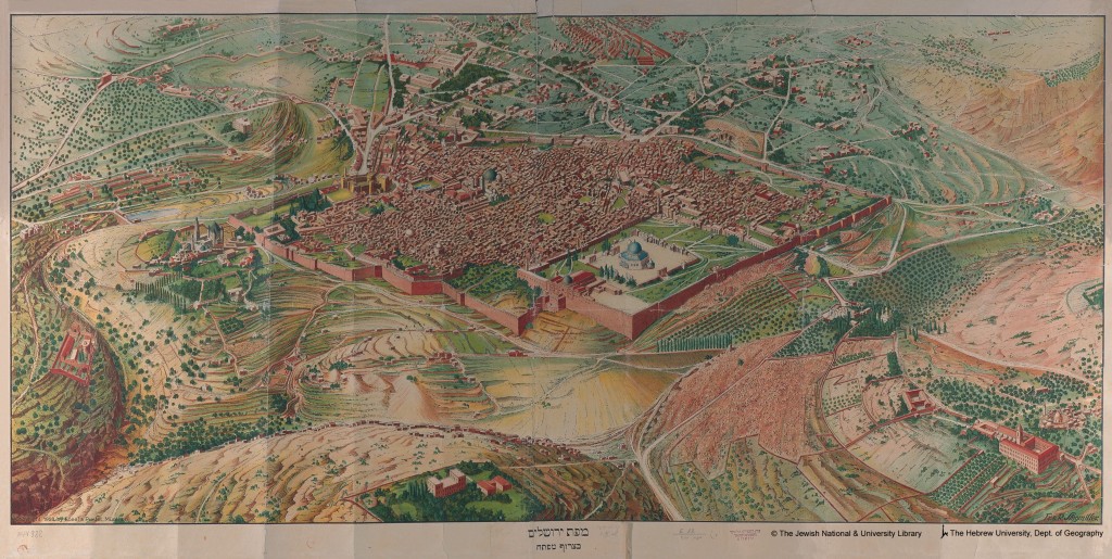
Moving across the Mediterranean now to one of the key spiritual and religious centres of the Middle East, I’d like to introduce a stunning topographical map of the city of Jerusalem. It shows the hills that surround this spectacular city. It also shows the ancient walls of the city, rebuilt on numerous occasions. The Dome of the Rock, the holiest place in Jerusalem can be seen in the lower part of the map (centre). For me Jerusalem is probably the most spiritually important city I’ve ever visited. It holds a key position in Jewish, Christian and Muslim faiths. This wonderful map dates from the 1940s and is from the collection of maps held at The Hebrew University – with thanks.
You can learn so much from maps. This next example is a silk scarf, with a map printed on it. It is a copy of a World War II map that was given to Allied Forces (British, American, Canadian, Australian) military personnel who were dropped by parachute, behind enemy lines in the 1940s. The scarf was a handy piece of kit, you could use it as a bandana, face covering or a bandage for a sprained ankle. Most importantly you could use it to orientate yourself once you’d recovered from the drop and were trying to work out your exact location. The back story to these ‘silk escape scarves’ is fascinating, I couldn’t resist writing about it. The silk escape scarf…

Last but not least, I’d like to include a superb, whimsical map that I recently commissioned from talented artist, designer and Geographer Bek Cruddace. I wanted a charming, and yet informative map of the island of Sicily that I could use to promote Sicily as a destination and also to illustrate my itineraries. Here’s what Bek came up with and I love it. I’ll be leading a small group tour to Sicily in October, 2021 – once normal life resumes! The map shows the key places we’ll visit in a leisurely and considered fashion.

My latest Veneto and Friuli Map is here too:

If you’ve got map stories you’d like to share you can drop me a line, contact details below. I’m always on the look out for interesting maps, especially pre-1960s, with an interesting story attached. Happy map reading!
Notes:
- Enquiries and comments welcome!
- For more on the lagoon of Venice – which fascinates me check out an article I wrote last year: Venice and the Lagoon, Italy
- I’ve also written a short piece about Ernest Hemingway here: Ernest Hemingway, Venetian Lagoon
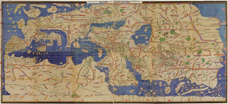
- The Treasures of Italy article that I wrote recently discusses the exceptional map created in the 12th century by Al’Idrisi – pictured below. This is actually a 1550 copy held in the Bibliotheque Nationale de Paris. Sicily – La Sicilia: Mediterranean jewel
- If you’ve enjoyed reading this – then do please explore further www.greyhoundtrainers.com for so many interesting articles!
- Happy Reading!
- Revised: 27-05-2020 / Updated: 15-07-2020
- Thanks for reading!


As fascinating as ever, Janice – in fact, more so! Despite over-exposure to map-reading in my teens in the School CCF (Cadet Force) I overcame my antipathy to maps soon became, as with you, a keen interest and dependance on them in later life -so I really enjoyed your comprehensive and really interesting account – thank you again.
John
PS Are you equally adept at map-reading in the car…..?! My Wife had me following a short cut between two unknown towns – and which turned out to be a fold in the road-map!!r
LikeLiked by 1 person